Weather kills pilots.
Not mechanical failure. Not running out of fuel. It’s not even pilot error in the traditional sense that kills pilots. Pilots flying into weather they’re not prepared for is a leading cause of general aviation accidents year after year.
The FAA knows this. That’s why weather theory fills an entire chapter of the Pilot’s Handbook of Aeronautical Knowledge, and why your instructor will spend hours drilling you on cloud types, fronts, and atmospheric stability before you solo.
In Flight Instruments: Reading What the Airplane Is Telling You, we covered the instruments that tell you what the airplane is doing. Now let’s talk about the invisible ocean you’re flying through and why understanding it might save your life.
The Atmosphere: An Ocean of Air
The atmosphere is a surprisingly thin shell of gases surrounding Earth. If Earth were the size of an apple, the atmosphere would be thinner than the peel.
Despite the relatively small size of the atmosphere, it’s everything. It’s what lets your wings generate lift. It’s what your engine needs to burn fuel to produce power. And it’s what creates every cloud, every storm, every gust of wind you’ll encounter.
Scientists divide the atmosphere into five layers based on how temperature changes with altitude. We’ll focus on the two that matter most to pilots.
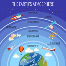
The Troposphere: Where Weather Lives
The troposphere is the lowest layer of the atmosphere, extending from sea level up to about 36,000 feet at mid-latitudes. It’s higher over the equator (up to 60,000 feet) and lower over the poles (around 20,000 feet).
This is where pilots live. More importantly, this is where weather lives.
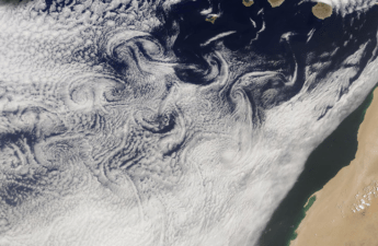
Nearly all clouds, precipitation, and weather phenomena occur in the troposphere. Why? Because this layer contains virtually all of the atmosphere’s water vapor, and water vapor is what makes weather.
The defining characteristic of the troposphere is that temperature decreases as you climb. Stand on the ground on a summer day and it might be 90°F. Climb to 10,000 feet and it’s probably closer to 55°F. Climb to 30,000 feet and you’re well below freezing.
This decrease in temperature with altitude is called the lapse rate, and understanding it is fundamental to understanding weather.
The Standard Atmosphere: A Reference Point
To give pilots and meteorologists a common baseline, the aviation community established the International Standard Atmosphere (ISA).
The standard atmosphere defines sea-level conditions as:
- Temperature: 15°C (59°F)
- Pressure: 29.92 inches of mercury (1013.2 millibars)
From that starting point, the standard atmosphere assumes:
- Temperature lapse rate: 2°C per 1,000 feet (about 3.5°F per 1,000 feet)
- Pressure lapse rate: Approximately 1 inch of mercury per 1,000 feet (up to 10,000 feet)
These aren’t laws of physics. They’re averages. The real atmosphere rarely matches standard conditions. But the standard atmosphere gives us a reference point for performance charts, altimeter settings, and weather discussions.
Lapse Rates: The Engine of Weather
The lapse rate is simply how fast temperature changes with altitude. But that simple concept drives almost everything about weather.
There are three types of lapse rates you need to understand:
Environmental lapse rate: The actual temperature profile at a specific time and place. This is what’s really happening in the atmosphere right now. It changes constantly and varies by location.
Dry adiabatic lapse rate: When unsaturated air (air without visible moisture) rises, it cools at about 3°C per 1,000 feet (5.4°F per 1,000 feet). When it descends, it warms at the same rate. This happens because rising air expands as pressure decreases, and expanding air cools — no heat is added or removed.
Moist adiabatic lapse rate: When saturated air (air containing visible moisture) rises, it cools more slowly — typically 1.5°C to 2.5°C per 1,000 feet. Why slower? Because as the air rises and cools, water vapor condenses into cloud droplets, releasing latent heat. That heat slows the cooling.
Why does this matter? Because the relationship between the environmental lapse rate and the adiabatic lapse rates determines whether the atmosphere is stable or unstable.
Atmospheric Stability: What Keeps Air Where It Is
Stable air resists vertical motion. If you force a parcel of air upward in stable conditions, it wants to sink back down. Stable air produces smooth flying conditions, stratiform (layered) clouds, and steady precipitation.
Unstable air encourages vertical motion. If you nudge a parcel of air upward in unstable conditions, it keeps rising on its own. Unstable air produces turbulence, cumulus (puffy) clouds, and thunderstorms.
Here’s how to think about it:
Imagine air at the surface that’s been heated to 25°C. It starts to rise. As it rises, it cools at the dry adiabatic lapse rate — 3°C per 1,000 feet.
If the environmental lapse rate is only 2°C per 1,000 feet, the rising parcel cools faster than the surrounding air. By the time it reaches 1,000 feet, the parcel is 22°C, but the surrounding air is 23°C. The parcel is now colder (denser) than its surroundings, so it sinks. The atmosphere is stable.
If the environmental lapse rate is 4°C per 1,000 feet, the rising parcel cools to 22°C at 1,000 feet, but the surrounding air has cooled to 21°C. The parcel is still warmer (less dense) than its surroundings, so it keeps rising. The atmosphere is unstable.
Unstable air is what creates thunderstorms. A parcel of warm, moist air starts rising and just keeps going — sometimes all the way to 50,000 feet or higher, building towering cumulonimbus clouds and violent weather.
Temperature Inversions: Stability on Steroids
A temperature inversion is when temperature increases with altitude instead of decreasing. This is the ultimate stable condition.
Inversions form in several ways:
Radiation inversions form on clear, calm nights. The ground radiates heat into space and cools rapidly. Air touching the cold ground also cools. But air a few hundred feet up stays warmer. Result: a layer of cold air trapped under warm air. You’ll see evidence of this on calm mornings with fog, haze, and smoke trapped near the surface, unable to rise through the warm layer above.
Frontal inversions form when a warm air mass rides up over a cold air mass. The warm air aloft sits above cooler air near the surface.
Inversions are important because they trap pollution, limit visibility, and can create hazardous icing conditions. But they also mark the top of bad weather. Climb through an inversion layer, and you’ll often break out into smooth, clear air.
Pressure: The Weight of the Air Above You
Atmospheric pressure is simply the weight of all the air above a given point. At sea level, the standard atmosphere exerts 14.7 pounds per square inch (about 29.92 inches of mercury).
Pressure decreases with altitude because there’s less air above you. Climb to 18,000 feet and pressure has dropped to about half of sea level pressure.
Pressure also varies horizontally. Some areas have higher pressure (highs), others have lower pressure (lows). Air flows from high pressure to low pressure, and that flow is what we call wind.
High-pressure areas are generally associated with descending air, clear skies, and stable conditions. Air sinking from aloft warms as it compresses, which inhibits cloud formation.
Low-pressure areas are associated with rising air, clouds, and precipitation. Rising air cools, moisture condenses, clouds form, and weather develops.
This is why weather forecasters obsess over pressure patterns. The location and movement of highs and lows tell the entire weather story.
Density Altitude: Why Hot and High Is Dangerous
Density altitude is pressure altitude corrected for non-standard temperature. It’s a measure of air density, and it directly affects aircraft performance.
Here’s the problem: as temperature increases or pressure decreases, air density decreases. Less dense air means:
- Less lift from the wings
- Less thrust from the propeller
- Less power from the engine
A Cessna 172 taking off from a sea-level airport on a cool day might need 800 feet of runway. The same airplane taking off from a 5,000-foot-elevation airport on a hot day might need 2,000 feet or more, and it’ll climb sluggishly once airborne.
High density altitude kills pilots who don’t respect it. The airplane feels normal on the ground. The engine runs fine. But when you try to take off, it won’t climb. By the time you realize you’re in trouble, you’re running out of runway and surrounded by trees.
The rule is simple: hot and high means poor performance. Calculate density altitude before every flight, and if it’s high, expect your airplane to perform like a much weaker version of itself.
Moisture: The Fuel for Weather
Water vapor is invisible, but it’s the single most important ingredient in weather. When moist air rises and cools, the water vapor condenses into tiny droplets which we see as clouds. Cool it further and those droplets freeze or coalesce into raindrops or snowflakes.
Three measures describe moisture in the air:
Relative humidity is the ratio of how much water vapor is in the air compared to how much the air could hold at that temperature. Warm air can hold more water vapor than cold air, so relative humidity changes with temperature even if the amount of water vapor stays constant.
Dewpoint is the temperature at which air becomes saturated and water vapor begins to condense. The closer the temperature and dewpoint, the higher the relative humidity. When temperature equals dewpoint, you get fog or clouds.
Temperature-dewpoint spread is simply the difference between temperature and dewpoint. A small spread (2-3°C) means high humidity and likely fog or low clouds. A large spread means dry air and good visibility.
Pilots monitor temperature-dewpoint spread obsessively, especially at night or in cool conditions. A narrowing spread warns that fog may be forming.
The Tropopause and Beyond
At the top of the troposphere sits the tropopause, which is a boundary layer where temperature stops decreasing with altitude. Above the tropopause lies the stratosphere, where temperature actually increases with altitude due to ozone absorbing ultraviolet radiation.
The tropopause acts like a lid, trapping moisture and weather in the troposphere. Thunderstorms sometimes punch through the tropopause, but most weather stays below it.
Commercial jets cruise in the lower stratosphere (35,000 to 41,000 feet) specifically because it’s above most weather, so there is little turbulence, no icing, and no thunderstorms. Just smooth, fast, fuel-efficient flight. Light aircraft rarely fly that high, but understanding the tropopause helps explain why weather behaves the way it does.
Why This Matters
Your instructor won’t let you solo until you can correctly interpret a weather briefing, decode a METAR, and explain why you shouldn’t fly into that towering cumulus cloud on a hot afternoon.
Why? Because weather knowledge isn’t academic. It’s survival.
You’ll learn to recognize stable versus unstable air by looking at cloud types. You’ll learn to calculate density altitude before every takeoff. And you’ll learn that “scattered clouds” at 3,000 feet sounds benign, but if those clouds are building and it’s a hot, humid afternoon, they might be the start of a thunderstorm.
Weather follows physical laws. Your job as a pilot is to understand those laws well enough to stay out of trouble.
Ready to see what you remember from this post? Take this quiz!