An acquaintance started his private pilot training and, much like me, his curiosity led to questions about things he hasn’t studied yet and doesn’t need to know yet. He asked me to put together a quick explanation of airspace and how VFR sectional charts depict it. This post is far from exhaustive, but it is a good start if you need a quick review or are just starting out looking at airspace around airports on VFR sectional charts.
Class B Airspace

Class B (often spoken as “class bravo”, or just “bravo”) airports have a solid blue line around them. Class B airspace surrounds the busiest airports in the country. There are only 37 class B airports in the United States.
You’ll notice that class C and class D airspace tends to have pretty standard shapes. Airspace designers always custom design Class B airspace for each airport. The Kansas City bravo in the picture above is actually pretty simple. Others can be very complex. Class B airports are busy enough that they don’t always let slower planes in since they have a harder time fitting into the flow of faster jet traffic.
One unique feature of bravo airspace is that pilots need an explicit clearance to enter. Simply establishing communications with the controller for Class C or Class D airspace is sufficient to enter that airspace. Not so with Class B. You must explicitly hear, “Cessna 123AB is cleared into the bravo”.
Class C Airspace
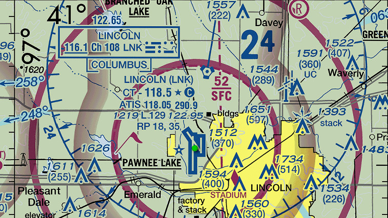
 Class C Airspace")
Class C (“Charlie”) airspace is depicted with a solid magenta line. This picture is of the Lincoln, Nebraska Class C. Lincoln is interesting in that the tower is part time. Over night it turns into a pilot controlled (some people use the term “uncontrolled”) field. That’s why the tower frequency is also marked as the CTAF frequency. After hours the tower frequency becomes CTAF. Check the Chart Supplement for details on operating hours.
Class D Airspace
 Class D Airspace")
Class D airspace is depicted with dotted blue lines. The example above is Grand Island, Nebraska. Class D airports are busy enough to need a tower, but they are not that busy. In some cases they don’t even have radar. They are usually part time towers that close overnight.
What About The Magenta Shading?
You’ll see quite a few airports with a magenta shaded line. You see it all over the sectional charts, and even see it surrounding the airports in the examples in this post. For the type of flying most private pilots will be doing, it doesn’t have a lot of practical impact.
This is a bit difficult to explain without going into the intricacies of class E and class G airspace first. Airports with the magenta shading are pilot controlled just like the airports without any shading. In simple terms, the magenta shading shows where the class E airspace is lowered to begin at 700 ft AGL compared to the typical 1200 ft AGL. (It is class G below this.) The purpose is to protect the space for instrument approaches in low visibility.
What Else?
You can spend days looking at sectionals finding all the stuff on them. I would challenge you to find any pilot of any experience level who can explain every symbol on a VFR sectional chart without looking at the legend.
Spend some time doing just that. Stare at the chart looking for things you never noticed before. Read through the legend. These charts have more information depicted that you could have imagined! If you have questions, send them to us.
If you don’t have an electronic flight bag, you can find current downloadable charts at the FAA web site. Several sites, including SkyVector, have an excellent online interactive sectional chart.