You can learn weather theory inside a classroom all day long. But the real education happens the moment you walk out to the flight line, look at the sky, and have to make a decision.
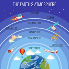
Is that cloud building or dissipating? Is that haze going to get worse? Should you go now, or wait? Weather judgment is one of the most important skills a pilot develops, and it starts with knowing how to read what’s above you. In Weather and the Atmosphere: What Pilots Need to Know, we covered the atmosphere itself: its layers, lapse rates, stability, and pressure. Now let’s put that knowledge to work and talk about types of clouds aviation pilots encounter every day, the weather fronts that bring those clouds, and how to think about weather systems as a pilot.
The Cloud Families: Altitude and Form
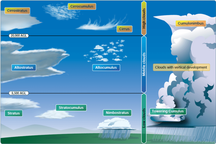
The FAA classifies clouds by two characteristics: altitude and form. Altitude tells you where the cloud lives. Form tells you whether the air is stable or unstable.
There are three altitude families and one special category.
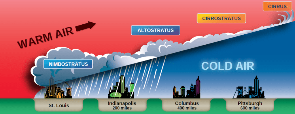
High clouds (cirro family): These form above 20,000 feet, where temperatures are far below freezing. They’re made entirely of ice crystals, not water droplets, which gives them a thin, wispy appearance. The main types are cirrus (thin, hair-like streaks), cirrocumulus (small, white puffs in rows or ripples), and cirrostratus (a thin, sheet-like veil that can create halos around the sun or moon). High clouds by themselves are rarely a hazard. However, cirrus spreading and thickening on the horizon is often the first sign of an approaching warm front.
Middle clouds (alto family): Altocumulus and altostratus occupy the 6,500- to 20,000-foot range. Altocumulus looks like rows of gray or white puffs — bigger and darker than cirrocumulus. Altostratus produces a gray or blue-gray sheet that often covers the entire sky. Altostratus is the weather cloud you want to watch. When it thickens to the point of blocking the sun entirely, precipitation is usually only hours away.
Low clouds (strato family): Stratus and stratocumulus form below 6,500 feet. Stratus is the flat, gray overcast that can drop ceilings to just a few hundred feet. Think of a foggy morning in San Francisco. It rarely produces more than drizzle, but it can absolutely trap you at a low altitude or close an airport. Stratocumulus is a lumpy, patchy version of the same thing. Nimbostratus is a dark, thick layer that produces steady, prolonged rain or snow.
Vertically developed clouds: Cumulus and cumulonimbus are in a category of their own because they don’t fit neatly into one altitude band, they grow vertically through multiple layers. Fair-weather cumulus are the puffy white clouds you see on a sunny afternoon. They’re usually harmless if they stay small and flat-based. Towering cumulus is the warning sign: they’re growing aggressively and indicate unstable air. Cumulonimbus is the fully developed thunderstorm cloud, and it is one of the most dangerous things a pilot can encounter.
Cumulonimbus: The Cloud That Can Kill You
It deserves its own section. A mature cumulonimbus (Cb) can extend from a base as low as 1,000 feet to tops above 50,000 feet. Inside, you’ll find updrafts and downdrafts of 100 mph or more, extreme turbulence, icing, hail, lightning, and wind shear at every altitude. The FAA is unambiguous on this point: do not fly into a thunderstorm.
The danger doesn’t stop at the edge of the cloud, either. Severe turbulence can extend 20 miles or more away from an active cell. Hail can be thrown outward from the top of the storm. Gusty surface winds and rapidly shifting wind direction often precede a cell by several miles.
The standard advice is to give a visible thunderstorm cell at least 20 miles of clearance. If you can’t go around it, you don’t go.
Weather Fronts: Where the Action Is
Most significant weather doesn’t appear randomly. It forms at fronts — the boundaries between air masses of different temperatures, densities, and moisture content. Understanding fronts is essential for interpreting forecasts and recognizing what weather is coming.
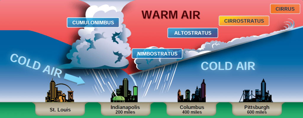
Cold fronts occur when a cold air mass moves in and undercuts a warmer air mass. Cold air is denser, so it slides under the warm air like a wedge, rapidly forcing it upward. That rapid lifting creates violent weather: squall lines, thunderstorms, and heavy precipitation along a narrow band. Cold fronts typically move fast (sometimes 25 to 35 knots) so the worst weather passes quickly. Behind the front, the air is usually clearer and cooler, with improving visibility and cumulus clouds.
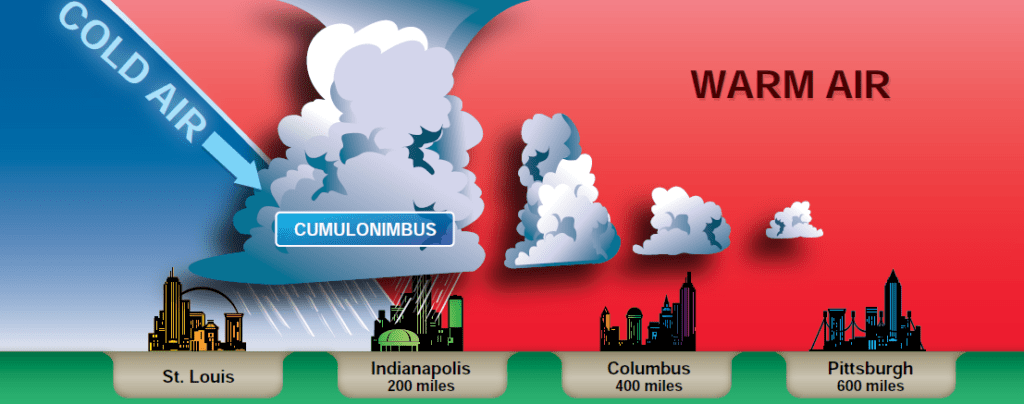
Warm fronts are the opposite scenario. A warm air mass advances and overrides retreating cold air. Because warm air rises gradually over a broad slope, the weather sequence develops slowly over hundreds of miles. Cirrus appears first, often a day or more before the front’s surface position arrives. Next come altostratus, then nimbostratus with steady precipitation. Warm front weather is less dramatic than cold front weather but can persist for much longer and produce low ceilings and poor visibility over a wide area.
Stationary fronts are exactly what they sound like: a boundary between two air masses that isn’t moving. The weather associated with a stationary front can linger for days. Alternating areas of cloud and precipitation can make flying difficult on either side of the front.
Occluded fronts form when a faster-moving cold front catches up to a slower warm front, lifting the warm air mass completely off the ground. The resulting weather can be complex — a mix of cold and warm front characteristics depending on the type of occlusion. These are common in the Pacific Northwest and can produce prolonged poor weather.
Reading a METAR: Putting Theory Into Practice
All the cloud theory in the world matters most when you apply it to an actual weather product. The METAR (Meteorological Aerodrome Report) is the standard aviation weather observation, updated every hour or more frequently. Every pilot needs to decode one before every flight.
Here’s a simplified METAR: METAR KSJC 051753Z 28015KT 10SM FEW025 SCT060 BKN120 18/07 A2992
The cloud groups tell the story. FEW025 means a few clouds at 2,500 feet AGL (Above Ground Level). SCT060 means scattered clouds at 6,000 feet. BKN120 means a broken layer at 12,000 feet. If you’re flying VFR, a broken layer is critical — it means more than half the sky is covered, and you need to stay below it or stay on the ground.
Cloud bases are always reported in hundreds of feet above ground level, not mean sea level. That distinction matters when you’re near terrain.
Fog: The Ground-Level Hazard
Fog is technically a cloud. It’s a stratus layer whose base is at or very near the ground. It’s one of the most common causes of VFR (Visual Flight Rules) flight into IMC (Instrument Meteorological Conditions), a situation that kills pilots every year.
Radiation fog is the most common type. On clear, calm nights, the ground radiates heat into space and cools rapidly. Air touching the cold surface also cools. If the temperature drops to the dewpoint, fog forms. Radiation fog burns off as the morning sun heats the surface, but it can persist until mid-morning or later in valleys and low-lying areas.
Advection fog forms when moist, warm air moves over a cooler surface. It’s common along coastlines, where warm ocean air drifts over cold upwelling water. Unlike radiation fog, advection fog can form quickly and persist regardless of wind. San Francisco’s famous summer fog is classic advection fog.
Upslope fog forms when moist air is pushed uphill by wind, rising and cooling until it reaches the dewpoint. Mountain airports are particularly susceptible.
Thunderstorm Development: Three Required Ingredients
The FAA Aviation Weather Handbook identifies three conditions necessary for thunderstorm formation: a source of moisture, a lifting mechanism, and an unstable atmosphere.
Moisture provides the fuel. Lifting can come from surface heating, a front, terrain, or converging winds. Instability allows the lifted air to keep rising on its own instead of sinking back down. When all three are present simultaneously, thunderstorms will develop.
A typical thunderstorm goes through three stages. The cumulus stage is the buildup phase, where strong updrafts dominate and the cloud rapidly grows vertically. The mature stage is the most dangerous: updrafts and downdrafts coexist, producing the most extreme turbulence, lightning, hail, and precipitation. The dissipating stage occurs when downdrafts dominate and cut off the inflow of warm, moist air. The storm weakens, but it can still produce significant wind and lightning during its collapse.
Pilot Weather Products: What to Check Before Every Flight
Cloud and front information reaches pilots through several official products.
METARs give you current conditions at reporting stations. Decode the cloud groups, visibility, and weather phenomena carefully.
TAFs (Terminal Aerodrome Forecasts) cover a 24- to 30-hour period for airports with sufficient traffic. They’re formatted similarly to METARs but represent a forecast, not an observation. Pay attention to tempo (temporary conditions) and probability groups — they indicate expected fluctuations.
PIREPs (Pilot Reports) are firsthand accounts from pilots already airborne. They’re often the most accurate real-time information about turbulence, icing, and cloud bases available.
SIGMETs and AIRMETs are advisory products covering significant weather hazards. SIGMETs cover severe conditions including convective activity, extreme turbulence, and icing. AIRMETs cover moderate hazards specifically for general aviation aircraft. Check both before every cross-country flight.
Why This Matters
Before your instructor signs you off for solo flight, you’ll need to demonstrate that you can interpret a weather briefing and explain why the conditions are or aren’t acceptable for flight. That requires knowing what types of clouds aviation rules and VFR minimums are designed to keep you away from.
Clouds are not just scenery. They’re data. A towering cumulus tells you the atmosphere is unstable and the afternoon might get violent. A thickening cirrostratus tells you a warm front is approaching. A rapidly narrowing temperature-dewpoint spread tells you fog may form after sunset.
Learn to read the sky, and the sky will start talking to you. Most of the time, it’ll tell you to go fly. Occasionally, it’ll tell you to wait. Listening to it either way is what makes a good pilot.
Think you remember everything from this post? Try the quiz!